

UGANDA A TRUE PEARL OF AFRICA
(Baganda Cultural Heritage)

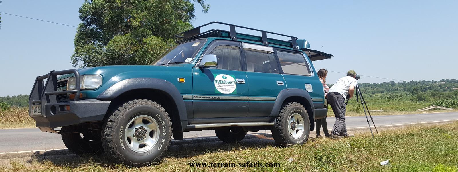
Tourists having a look around Bulange on one our cultural tours.
The East African/Great Lakes region has a rich cultural heritage, characterized by the renowned cattle keeping tribes. These include the Masai in Kenya and Tanzania, the Karamojong & Banyankore in Uganda plus the Tusi in Rwanda and Burundi.
Uganda being known for abundant wildlife, birds, great weather, breath taking landscapes, fresh water & crater lakes. These are toppled with also a rich diversity of untapped culture and heritage, characterized by the Baganda culture, practiced by the people of “Buganda”, central Uganda.
With Over 56 tribes, Uganda is definitely the ultimate place to experience the diverse cultural immersion. Ranging from cultural music, food, art, and hand crafts to the cultural norms, the rituals, and royal regalia the experience is unmatched. With three distinct linguistic groups namely the Bantu, Nilotic, and the central Sudanese people. Each encounter, presents you with a different set of practices and beliefs.
The central region is mostly inhabited by the Bantu specifically the Buganda whose history is mostly synonymous with that of Uganda. Other Bantu tribes include the Banyoro, Bakiga, Banyankole, Bahima, Batooro, in western Uganda, Basoga, Bagisu, Bagwere in Eastern Uganda, then the northern and eastern area of the country are mostly the Nilotic who include the Iteso, langis, Alur, Karamojongs, to mention but a few.
These were the first cattle herding people in the area, but later relied on cultivation to supplement their livestock. The central Sudanic people most of whom live in the north western part of the country include the bugbara, Alurus, madis’, among others speak a similar language and have strong cultural similarities.
Although there are numerous languages spoken across the country there are two official languages which are English and Swahili. Like it is in many countries, dance is one of the most important part of most of the cultural ceremonies along with songs something you can experience on your cultural trip in Uganda. Other traditional rituals such as marriage, birth rites, and initiation are very important in the different cultures and may vary significantly.
There is also a great wealth of Archeological, historical and religious sites that offer a great experience and in-depth understanding of Uganda. Join us at terrain safari limited to explore the cultural diversity of Uganda tailoring a package of your dreams based on your needs and enjoy the warmth and hospitality of the people of Uganda.
TTANDA SHRINE – GANDA CULTURAL HERITAGE.
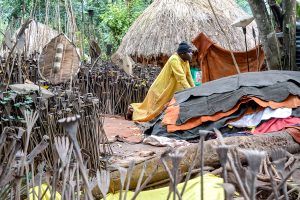
This is a Ganda cultural site found in Mityana, Singo County, in Buganda – Uganda. The shrine lies about 48 kilometers, west of Kampala, on Fort-Portal road. Tanda pits are found in Tanda village, Mityana district, about an hour’s drive from Kampala. There are over 240 circular pits about 12 feet deep and 2 shrines in an enclosed reed fence. These are archaeological sites of Buganda kingdom. There are so many myths about Tanda and how Kintu and his wife Nambi came to the earth and met Kayiikuuzi – Walumbe at this place.

According to folklore, the pits are known as Enyanga za Walumbe or the home of Walumbe which means the god of death among the Baganda, the spirit is associated with diseases and death. According to the department of antiquities and museums, Tanda pits were first documented in 1920 by E.J Wayland having seen locals going there to worship the gods. Tanda pits is a sacred religious site where people go and allegedly given power to communicate with spirits and get healed of misfortunes.
The same god (Walumbe), turns to (Kabaka Bulamu), according to the locals, after one visiting the shrine, worship and perform the rituals required to be righteous before the god of death.
Tanda pits folktales
There are several mythological figures of Walumbe but the common one has it that the first man on earth Kintu lived with his beloved cow depending on it’s milk and cow dung. And Ggulu(the creator) lived in heaven with his three children that is to say; Walumbe, Kayikuzi and Nambi.
On several occasions Nambi and her brothers descended on earth to play and adventure. On one of their visits they met Kintu grazing his cow. Nambi liked Kintu and when she went with him to heaven, asked her father so she can get married to him. Ggulu wasn’t pleased with the idea of their marriage at first but after persuasion they were blessed and allowed to marry each other. Among the siblings Walumbe was not happy with the union and promised to wreck their marriage. Noticing this Ggulu advised Nambi and Kintu to secretly leave heaven so that Walumbe doesn’t follow them.
The next morning they prepared for the journey with a few things Nambi had packed including chicken. As they were descending to the earth, Nambi remembered that she forgot millet for her chicken. Kintu tried to persuade her not to go back but in vain. Along the way she met Walumbe and didn’t tell him where she was going. But the spirit followed her and eventually the couple came with him on earth. It is believed that his arrival in Kintu’s home was the start of sickness, misery and death.
Ggulu upon hearing the suffering and misery in the Kintu family, he sent Kayikuzi to bring back his brother Walumbe. Walumbe didn’t want to go back so he fought with Kayikuzi and dug pits to hide which still act as a testimony for their fight. The spirits of Kayikuzi and Walumbe are still believed to roam the area in fascinating ancient folklore that is still retold to the generations. One of the tales is associated with earthquakes that are said to result from the fighting between Kayikuzi and Walumbe.
Today, the place is covered in thick forest as it is believed that the ancestors preferred trees and also gives the pilgrims a good environment to rest. The main shrine known as Embuga Ya Kabaka Bulamu – Ettanda is the biggest pit and believed to be where Walumbe disappeared to earth. The Caretakers covered the pit with three pieces of backcloth to distinguish it from others. The main entrance to Tanda pits is built in the form of shrines with traditional instruments like spears, calabashes and shields among other cultural items. Among the taboos, women are not supposed to eat chicken & eggs in this place, sit on chairs and put on mini outfits or trousers. Here all the locals have to put on according to the cultural norms and traditions. The men put on kanzus and women put on busutis.
Those visiting, especially pilgrims are required to remove shoes as they enter the main shrine. They usually come for healing and pray for blessings, peace, love and prosperity in their social and economic endeavors including those who wish to bear children. They pay homage to Walumbe, gods and deities. They perform rituals and give offerings such as coffee beans, cows, goats, chicken, fruits, water and local brews made from banans and sorghum called Tonto. Walumbe reveals himself to pilgrims through dreams as a sign of healing and it works more for those that believe and have faith in them, just like these other religions such as Anglican, Catholic, Islam and others.
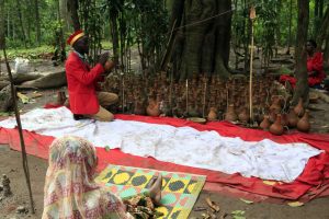
It is believed the Ttonda is the most high God and that these other small gods are his children. So the local pray to Ttonda through his children – Kabaka Bulamu, Ssewamala, Walusinsi, Kiwanuka, Musoke, Mukasa, Lubowa, Nambaga, Namuzinda, Kkubo, Bamweyana, Kibuuka, Namuganyi, Nakayima, Kaliisa, Ddungu, Nabinene, Nabawanuka, Namalele, and many others. There are several fireplaces ( Ebyooto in Luganda) outside the shrines dedicated to various gods which are associated with Walumbe and the locals make fire for each of these gods for deferent prayer purposes.
For instance, at the Embuga ya Dungu, a shrine for the god of hunters has animal horns, bells, spears and nets surrounding the fireplace. Pilgrims who dream about slaughtering or roasting animals bring them here to pay to the custodians of the shrine. Another shrine is called Embuga ya Wanema where those who dream of seeing people with crutches go and pray to be healed. There is also Mbuga ya Bamweyana, the god of prosperity, where people offer baskets, alcohol, tobacco, marijuana and khat because it is believed that the god takes those drinks.
The Embuga ya Kiwanuka, the god of war and army is responsible for inciting chaos among people. The place is surrounded by red clothes because the god likes blood. Pilgrims offer honey and banana juice only believing that this god moves in Mukokowe (Ficus Brachiopod) tree. At the Embuga ya Musoke, a shrine for the god of rain is dedicated to people who dream about drinking water for blessing and sharing it with their ancestors. After dreaming they go there to fetch holy water from Musoke well for drinking. At times women are found peeling matooke and pounding groundnuts which signifies that these women dreamt of preparing a meal of matoke with groundnut stew to eat and share it with their ancestors. Such a meal is called ekijjulo kya ba jajja.
The Embuga ya Mukasa, a shrine for the god of water and fish has boats, pots with water and oars and the only place where eating fish is permitted. It is believed that the god was a fisherman. For cattle keepers there is always a fire burning place for Kalisa (cattle keeper) where fire keeps on burning with only cow dung. The cultivators make offerings to the deity known as Mama Nalongo Nabinene and give in things like banana, gomesi, millet, sim sim, maize, traditional hoes and knives. There are other shrines for gods like; Wamagobye, matriarch Nakayima and Jajja Muwanga.
Tanda is an important place among the Baganda, however the king of Buganda (Kabaka) does not visit the place given that it’s a taboo. Further, when Kabaka appreciates the work done by the people at Tanda pits, he directs them to slaughter a cow or goat as a sacrifice. The site is managed by the Buganda Tourism Board and is growing to become a cultural and religious site that attracts many worshipers from different religious background to convene at Tanda pits to seek for blessings. The entrance fee for this traditional/cultural site is 3,000/= per person and other activities are charged accordingly.
NAKAYIMA CULTURAL TOURIST SITE.

Nakyima Tree, cultural sites, Mubende.
Nakayima cultural site is found on Mubende hill approximately 3 ½ hours’ drive from Kampala. Nakayima tree is a rich heritage site that should not be missed by tourists on safaris in Uganda. Nakayima Tree is found in Mubende. This is ancient witch tree, the base of which has a large buttress roots, sited on top of Mubende hills about 4km out of the town.
This is a 2.13 miles hill with a flat table top where the ancient palace once stood, provides an excellent view of Mubende town and the surrounding area. The tree is estimated about 650 years old following the tests that were carried out in 1989 by researchers and it serves as a shrine of the spirits of Nakayima, the first wife of the Bachwezi King Ndahura.
The shrine is visited by people playing homage to Nakayima or Bachwezi a dynasty said to have supernatural powers. The tree is believed to be the spiritual home for the Bachwezi goddess respected by both the Baganda and the Banyoro. The Fig tree derives it’s name from the lineage of princesses belonging to the royal family and is a worship center where traditionalists come and pray for whatever they want and is given to them.
The large tree roots form 18 rooms of which four of them are noted to have belonged to Ndahura and can be seen while on tour in Uganda. Following the emergence of small pox and the collapse of the Bachwezi rule, the hill reverted to it’s former state as the sorceress abode though with a distinction. The Ndahura’s memory who had become defied as the god of small pox was perpetrated at the site through this woman who then took up the name of Nakayima (Nyakhima) giving every successive priestess that name other than own name up to the last holder (Nyanjara) who faced the demise in 1907.
Over the centuries, Nakayima has always had great power and was recognized across the borders of Bunyoro – Kitara and Buganda. Nakayima tree is a good spot for tourists on their way to Kibale National Park for chimpanzee tracking, Fort Portal or Rwenzori Mountains National Park. A stop at this enormous tree can last between 30 minutes to 1 hour as you go through the history of the place. Although it is less known as a tourist attraction, Nakayima Tree is gradually turning into tourist site.
At the site, there is a guide who stays on top of the hill responsible for giving tours of the area and explaining the cultural and historical significance of the tree. The tree looks old and wise, large and gnarly, with a very distinctive look to it. As you are there, you see people who gather to pay their respects and make offerings to sacred spirits who live in the tree. Each section of the tree is associated with a different spirit and there are spirits for different aspects of life.
MINING AT KATWE SALT LAKE, (QENP. – UGANDA)

Tourists at Katwe Salt Lake, Queen Elizabeth National Park.
Paid a visit to Katwe salt lake this morning and learnt a lot about salt mining at the lake. Lake Katwe is located in Western Uganda, Kasese district- and lies on the bottom of Albertine, the western arm of the Great East African rift valley. The water in this lake is 60% salty. The region is semi-arid and the soil doesn’t favor agricultural activities and therefore the major economic activity here is salt mining. Katwe salt industry is the main source of income among the inhabitants.
They are still practicing rudimentary mining of salt which helps them to make a living. Among the many economic activities carried out by the locals in Uganda is the salt mining at Katwe salt lake. Katwe salt lake is one of the only 2 productive salt lakes found in the northern sector of Queen Elizabeth national park.
Due to the volcanic eruptions that occurred in this area millions of years ago. A number of explosion craters were formed in this area, some with water and some without water. So among the ones with water, are the 2 productive salt lakes, Katwe and Bunyampaka. Bunyampaka salt lake is relatively small as compared to Katwe salt lake, hence Katwe aiding the main salt production in the area. This lies below the foothills of Mountain Rwenzori, on the bottom of the Albertine Rift Valley. The salt here is locally extracted and used as it is, not refined.
How is salt locally extracted?
This lake has shallow water, so the locals make pans within the lake and live them for 4 to 5 days for the salt to come on top. They later collect it and make heaps on the side of their pans. The salt is got in different colors, but they do not refine it. It is used as it is and most of it is used for livestock feeding. Did you know that when men are going into the lake to extract the salt, they are advised to put on condoms as one of the protective/safety gears? They do this as one of the safety measures to avoid being affected by the highly concentrated salt water. Visit it the lake today to learn more of the activities done here.
The type of salt extracted from Lake Katwe include;
• Salt grade 1 washed (sodium chloride nacl); which is produced by evaporation in mud- lined ponds commonly known as ‘salt pans” of average size 13×18 feet. This salt is high quality for human consumption.
• Salt grade II (crude salt) ; This is the by-product obtaining during the process of preparation for salt grade II washed This salt is for human consumption and crude for animal consumption
• Salt grade III (Rock salt); This type of salt is in rock form and it is extracted at the bottom of the main lake by men called “Rock salt Extractors” This salt is usually for animal consumption.
Salt Mining Seasons.
There are two seasons of harvesting salt. That is from January to March and from July to September when there is much sunshine. Salt traders come from nearby markets in Uganda and from other countries like Congo, Rwanda, Sudan and Tanzania. Salt has been extracted from this lake since the 13th Century. It’s mined from small plots. These “plots” are ponds 10 by 12 feet or so wide and 3 to 5 feet deep.
They are demarcated on the shores of the lake, owned by private individuals or families and inherited. Mining in the center of the lake is only done by licensed individuals. The association for Rock Salt Extraction issues the licenses for extraction of rock salt from the middle of the lake. This type of arrangement was made to ensure that the salt is extracted in an orderly process without causing extinction. This salt is high quality salt for human consumption.
The history of salt mining in Katwe.
The salt mining by the locals has been going on in this area since the 13th century, as one of the reliable economic activities for the Basongola people. The indigenous people of this area are Basongola, who are naturally cattle keepers. Their lifestyle changed when they got invaded by the Tsetse flies. The epidamic killed many of them plus their cattle, that led to most of the remaining people to flee the land. The ones that remained behind resorted to doing other activities because they had cattle left. So salt mining rescued them as the alternative income earner.
In the 1970s when Idi Amin Dada was the President of this country, they tried to construct a salt factory in this area and a storied structure was put in place. But unfortunately the surveyors did not do their job properly, that they put still pipes in the salt factory and by the moment they started putting salt water in these pipes, everything clotted and that was the end of the production. So the factory did not produce even one kilogram of salt and until now the factory (structure) is still sitting empty in this area. This was a total wastage of resources, but luckily the locals are now doing the mining job, the African way and earn a living for their families’ survival.
SEMPAYA HOT SPRINGS & THE BATWA (PYGMIES) CULTURE:

Tourists at Sempaya female hot springs, Semliki national park.
The Batwa (Pygmies) people are known to be hunters and fruit gatherers, who lived in Semiliki forest before it was gazetted as a conservation area. Sempaya hot springs are found in Semiliki National Park. These hot springs have a geyser shooting up from an eight-meter wide hole at hot temperature famous for the Sempaya male and female hot springs.
The deference between the male and female hot springs came about way back in the pre-historical times, when the Bamba & the Batwa locals used to come to this area for thanks giving to their gods and the men would do it from their side and also the women from their side, hence naming the 2 hot springs accordingly.
Semiliki National Park covers an area of about 220 square km and is one of Uganda’s newest National Parks having been gazetted in October 1993. There is however a number of natural hot springs in this area, which attracts a number of wetland birds, and supply salty minerals to these animals. These hot springs have attracted many safari tours to Uganda, which has helped in raising high revenues to the country.
Sempaya hot springs is considered to be a mosaic of different micro habits which provide a variety of wildlife. It is the only park in Uganda composed primarily of tropical lowland forest. The land is flat, creating a startling contrast to the rugged Rwenzori Mountains nearby. The Semiliki River is a favored watering point for many animals resident in the park. The animals which are found in this park include; elephants, buffalo, leopards, civet, scaly tailed flying squirrel, bush baby and the pygmy antelope.
The park has also got 8 species of primates which include the grey-checked mangabey, the red- tailed monkey, chimpanzees, and the De brazza’s monkey among others, plus 400 bird species and 300 butterfly species. Visitors also engage in nature walks in established trails, and also arrange hikes to different parts of the park. The sempaya hot springs are considered to be the famous attraction in Semliki national park.
The hot springs have got amazing boiling water which ejects conspicuous cloud of steam seen as far as 2kms. Interestingly, one can boil food like eggs in the natural boiler within ten minutes and eat. The steam bubbles up from the depths of the earth to demonstrate the powerful subterranean forces that have shaped the Rift Valley many centuries ago. This therefore has helped in increasing the number of visitors flow to the area.
Imbalu Ceremony (The Bamasaba way of turning boys into Men)
Every August, many Bagisu or Bamasaba boys are initiated into manhood. The Bagisu inhabit the western and southern halves of mountain Elgon in the Eastern Uganda. The boys mostly between the age of 12 and 16 undergo a traditional circumcision ritual called ‘Imbalu’ This process is done without any anesthetics. Imbalu in Lugisu literary means a big knife.
In Bugisu, the main ceremony in the region is always held at Mototo, one kilometer out of Mbale town. Mutoto not only brings together Bamasaba from Uganda but also Kenya. Mutoto is said to be the place where the first Imbalu ceremony took place and up to date all the subsequent Imbalu ceremonies have taken place. Mutoto is equated to Namugongo or Mecca where thousands of pilgrims’ throng annually.
The Imbalu is believed to have been carried out purposely for the safety of the boys especially. So after a Mumasaba boy bruised his foreskin during intercourse with the girl. This is part of their culture now that identifies them. However, it is also believed that Imbalu originated from the demand by the Kalenjin when Masaba, the Bagisu hero ancestor, wanted to marry a Kalenjin girl and so was forced to circumcise.
Yet another legend says the first person to be circumcised was being punished for seducing other people’s wives. After he was caught, it was decided to partially ‘castrate’ him by way of circumcision. When he recovered he resumed his former practices and rumor went around that he had become excellent at sex. So in order to compete favorably, other men decided to also circumcise.
The circumcision ceremony is preceded by the ‘Candidates’ moving around the villages as they dance to Kadodi, a rhythmic drum-beat unique to Bugisu meant for the ceremony. The boys wear only shorts with a bare chest. They are subjected to hard conditions as one of the ways they can prove that they are ready to be men.
The dances last between one and four weeks, depending on each family’s preference. In some cases, one week to the circumcision date, some families treat the boys to a local drink made of fermented millet, Malwa, mixed with hot water. The initiation into drinking implies that the boys are due for the right of passage; on circumcision day, elders smear the boys to be circumcised with ash. It makes them look like warriors which psychologically prepare them for the surgeon’s knife.
Once they have undergone the circumcision, assistants sprinkle a powdered herb called Ingu on the freshly circumcised penises to quicken the healing and in many cases, the wounds reportedly dry in three weeks. After the circumcision, the ‘graduates into manhood’ are fed on Bushera- millet porridge. They are also fed on pumpkins and the chicken they got because they are rich in protein.
So all that and more can be explored if you book your cultural tour with us “Terrain Safaris”.
COME EXPLORE THE BEAUTY OF THE NYERO ROCK PAINTINGS
The Nyero rock paintings are located in eastern Uganda in Kumi District, 8 km (5.0 miles) west of Kumi town, about 200 km (124.3 miles) from the capital city Kampala. The Nyero rock paintings are among the most important rock art in Uganda. If you have an interest in archeology then the Nyero Ancient Rock Paintings Caves are a site to be visited especially if you are driving by or from Kidepo Valley Park.
This is a perfect place to enjoy a picnic, the morning sun and above all once you can climb up on top of the shelter, you will have great views of the surrounding area, find monkeys – birds and at times even reptiles sunbathing. This is quite fantastic and memorable. It’s believed that no one knows who drew these beautiful paintings and therefore no records written left. Nevertheless, no matter who drew them, many come to admire the Nyero Ancient Rock Paintings Caves round.
And each of them give you some local stories that go with them which make this a most interesting stop and another cultural look back at early history of Uganda/Africa. In 2010 the US donated some money to preserve the rock paintings and the site since they are in danger of eroding and literally fading from history. Ugandans has also spoken about developing the site more for visitors which would also be of benefit to the local community and the village.
The nyero rock site has six shelters which are;
Nyero 1; This is a small rock shelter formed by a low overhanging rock perched above three supporting rocks. On the outer edge of the overhang are six sets of concentric circles in white, together with paintings in the shape of ‘acacia pods’.
Nyero 2; This is the main shelter, it has a 10 m (32.8 ft.) high vertical rock against the back wall and an overhang formed by the breaking away of an enormous boulder estimated to weigh at least 20,000 tons. The overhang protects the paintings from direct rain and rocks in front and to the sides protect the paintings from the sun. The paintings are all done in shades of red. Concentric circles are the dominant form and more than forty different drawings were identified.
There is one large ‘acacia pod’ design that has also been called a canoe. On the south-eastern side of the shelter, a narrow passage between the boulders leads to a small, dark shelter where there is a small cavity known as the ‘pocket’ where the early inhabitants used to offer gifts to their gods after receiving help from them. Members of the local community still follow a tradition of placing money there either before or after receiving help from ancestral spirits.
Nyero 3; This shelter is at the far northern end of the Inselberg and about 8 minutes’ walk from Nyero 2. It is formed by a large boulder perched on top of supporting rocks with no standing room. Once inside the artificial protecting wall, visitors have to crouch low down to reach the far end where another artificial wall makes it less dangerous and allows a wide view of the land below. The paintings are white concentric circles; the outer circles are surrounded by double curved designs, between which are double lines divided into smaller compartments.
Nyero 4; This is a small shelter on the south-western side of the hill where there are a few traces of red finger-painted concentric circles, two conical shapes and lines.
Nyero 5; This is situated on the western side of the hill near to the primary school, has a red geometric motif composed of a combination of circular and linear shapes made with both a brush and a finger. Unfortunately, part of it has been damaged by natural water erosion.
Nyero 6; This is situated high on top of the hill and has a good view of the surrounding countryside. There are traces of red pigment forming two finger-painted outlines of small oval shapes and a slanting L-shape as well as an outlined cross with a small circle below. At terrain safaris (www.terrain-safaris.com) we shall include this site in the itinerary once you book with us a safari to kidepo valley national park.
Book your East African Cultural Tour Today:
Here are some of our tours; Uganda Cultural Tours, Rwanda Cultural Tours, Kenya Masai Cultural Safaris, Tanzania Masai Cultural Tours.
Thank you for supporting Terrain Safaris and always remember to follow the COVID 19 safety measures and guidelines from the Ministry of Healthy.
For safari inquiry press the button below;
